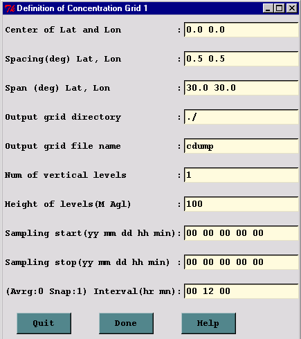
This section is used to define the grid system to which the concentrations are summed during the integration and subsequently for post-processing and display of the model's output. There are 10 entries in the CONTROL file for each concentration grid that has been defined. The lines 16(1) through 25(10) correspond with each of the menu items shown in the illustration below.
Dispersion calculations are performed on the computational (meteorological) grid without regard to the definition or location of any concentration grid. Therefore it is possible to complete a simulation and have no results to view if the concentration grid was in the wrong location. In addition, very small concentration grid spacing will reduce the model's integration time step and may result is substantially longer simulation clock times.
15- Number of simultaneous concentration grids
Default: 1
Multiple or nested grids may be defined. The concentration output grids are treated independently. The following 10 entries will be repeated for each grid defined.
In the special case with the first grid heights above ground level and the second grid heights above mean sea level, this value is set to negative 2, and the MSL flag is not set. Similarly if this value is set to negative 4, the first and third grids are referenced to ground level, the second and fourth to mean sea level. (See section "Height of each level" below.)
16(1)- Center Latitude, Longitude (degrees)
Default: [source location]
Sets the center position of the concentration sampling grid in degrees and decimal. Input of zero's will result in selection of the default value, the location of the emission source. Sometimes it may be desirable to move the grid center location downwind near the center of the projected plume position.
17(2)- Grid spacing (degrees) Latitude, Longitude
Default: 1.0 1.0
Sets the interval in degrees between nodes of the sampling grid. Puffs must pass over a node to contribute concentration to that point and therefore if the spacing is too wide, they may pass between intersection points. Particle model calculations represent grid-cell averages, where each cell is centered on a node position, with its dimensions equal to the grid spacing. Finer resolution concentration grids require correspondingly finer integration time-steps. This may be mitigated to some extent by limiting fine resolution grids to only the first few hours of the simulation.
In the special case of a polar (arc,distance) concentration grid, defined when the namelist variable cpack=3, the definition changes such that the latitude grid spacing equals the sector angle in degrees and the longitude grid spacing equals the sector distance spacing in kilometers.
18(3)- Grid span (deg) Latitude, Longitude
Default: [180.0] [360.0]
Sets the total span of the grid in each direction. For instance, a span of 10 degrees would cover 5 degrees on each side of the center grid location. A plume that goes off the grid would have cutoff appearance, which can sometimes be mitigated by moving the grid center further downwind.
Grid span and spacing should be set according to the scale of the run. Small scale runs can have fine spacing and small span; the opposite for large scale runs.
In the special case of a polar (arc,distance) concentration grid, defined when the namelist variable cpack=3, the definition changes such that the latitude span always equals 360.0 degrees and the longitude span equals the total downwind distance in kilometers. Note that the number of grid points equals 360/arc-angle or the total-distance divided by the sector-distance.
19(4)- Enter grid # 1 directory
Default: ( \main\sub\output\ )
Directory to which the binary concentration output file for this grid is written. As in other directory entries a terminating (\) slash is required.
20(5)- Enter grid # 1 file name
Default: file_name
Name of the concentration output file for each grid. See Section 6 for a description of the format of the concentration output file.
21(6)- Number of vertical concentration levels
Default: 1
The number of vertical levels in the concentration grid including the ground surface level if deposition output is required.
22(7)- Height of each level (m)
Default: 50
Output grid levels may be defined in any order for the puff model as long as the deposition level (0) comes first (a height of zero indicates deposition output). Air concentrations must have a non-zero height defined. A height for the puff model indicates the concentration at that level. A height for the particle model indicates the average concentration between that level and the previous level (or the ground for the first level). Therefore heights for the particle model need to be defined in ascending order. Note that the default is to treat the levels as above-ground-level (AGL) unless the MSL (above Mean-Sea-Level) flag has been set (see advanced configuration).
23(8)- Sampling start time: year month day hour minute
Default: [simulation start]
Each concentration grid may have a different starting, stopping, and output averaging time. Zero entry will result in setting the default values. Default values are to use the simulation starting time (1). "Backward" calculations require that the stop time should come before the start time.
If the month field is zero, then the minute and hour fields in the sample
start will be used to set the sample start time relative to the simulation start time (1).
For example, if the simulation starting time is 18 10 31 05 and the sample start is set
at 00 00 00 02 00 then the sample start time will be at 18 10 31 07 00.
24(9)- Sampling stop time: year month day hour minute
Default: [One year from simulation starting time]
After this time no more concentration records are written. Early termination on a high resolution grid (after the plume has moved away from the source) is an effective way of speeding up the computation for high resolution output near the source because once turned-off that particular grid resolution is no longer used for time-step computations.
Zero entry (00 00 00 00 00) results in setting the default values. Default values are one year from the simulation starting time (1). (Or one year before the simulation start in the case of backward runs)
If the month field is zero, then the minute and hour fields in the sample
stop will be used to set the sample stop time relative to the sample start time (23(8)).
This was implemented in V985.
For example, if the sample start is set to 18 10 31 07 00 and the sample stop
is 00 00 00 05 00 then the sample stop will be set to 18 10 31 12 00.
25(10)- Sampling interval: type hour minute
Default: 0 24 0
Each grid may have its own sampling or averaging interval. The interval can be of three different types: averaging (type=0), snapshot (type=1), or maximum (type=2). Averaging will produce output averaged over the specified interval. For instance, you may want to define a concentration grid that produces 24-hour average air concentrations for the duration of the simulation, which in the case of a 2-day simulation will result in 2 output maps, one for each day. Each defined grid can have a different output type and interval. Snapshot (or now) will give the instantaneous output at the output interval, and maximum will save the maximum concentration at each grid point over the duration of the output interval. Therefore, when a maximum concentration grid is defined, it is also required to define an identical snapshot or average grid over which the maximum will be computed. There is also the special case when the type value is less than zero. In that case the value represents the averaging time in hours and the output interval time represents the interval at which the average concentration is output. For instance, a setting of {-1 6 0} would output a one-hour average concentration every six hours.