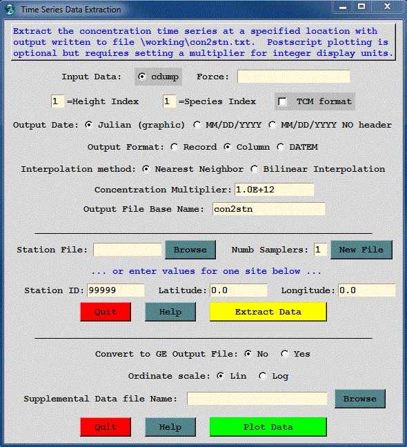
The purpose of the Convert to Station utility menu (also called time series data extraction) is to list concentrations at specific latitude-longitude locations by extracting that information to a text file. The menu also has an option to produce a time series plot at one or more of the stations or a KML formatted file suitable for display by Google Earth. An illustration of the menu is shown below. The concentration grid names are determined from the Concentration / Setup Run menu tabs and therefore the setup menu needs to be called prior to opening this menu. The species and height values are index numbers starting at one. A height index of 1 is the data at the first output level, regardless of its actual height value. The date field can be written as a fractional Julian day (for plotting) or using a MM/DD/YYYY field (for spreadsheets) with or without an index record. The no index record option is used to concatenate multiple files.
The TCM checkbox is used to flag the input file as having been created using the ICHEM=10 namelist option. There is no specific marker in the concentration to indicate that the file is in this format. The file contains multiple pollutants, each associated with a different time of release. The TCM flag also causes the first output time group with each record to be associated with the time of release rather than the time of the sample collection. The second time group of the record becomes the start time of the sample collection.
Similar to the other menus in the utility section, the input concentration file must be defined in the Concentration Setup menu. The menu options correspond to the command line options of the con2stn extraction program. There are two options that can be used to define an extraction location. A station location can be defined directly as an entry in the menu, or a list of stations can be defined using an input file. If the input file does not exist, it can be created by using the New File button. In this example illustration, a file has been defined with three locations that are within the plume of the example simulation. The file consists of three records, one for each station:
![]()
The extraction program is called con2stn and for these three stations, produces the output file shown below, called by default con2stn.txt. The base name of the output file (con2stn) can be changed in the menu. In contrast to the simulation shown in all the previous examples, in this case the output averaging time was decreased from 12 hours to one hour, to generate a smoother looking graphic.
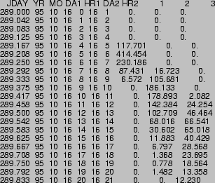
The output file shows the Julian day, month, day, and hour of the sample start; day and hour of sample ending time, and the concentrations for each station (location selected by latitude-longitude). The format of each output record is as follows:
The lower section of the GUI is used to create a simple time series concentration plot of the concentration time series or an output file (con2stn.kml) suitable for display by Google Earth. The con2stn.txt file is created first which is then read by the Google Earth conversion program (stn2ge).
For time series data, one or more stations may be plotted. The plotting feature is also available through the command line. The option is selected from the Display Time Series checkbox. The program, timeplot, reads the data file produced by the con2stn conversion program and plots the concentration values to the timeplot.ps output file. The illustration for the previous text file is shown below.
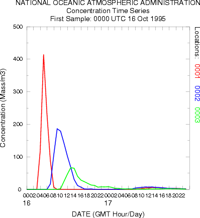
There are only two plot options supported through the GUI: linear or logarithmic ordinate scaling. If integer ordinate units are desired then it may be necessary to specify a units conversion factor, in this case 1015, to create data in the text file that can be plotted. With the log scaling option, the conversion factor can be set to 1.0, and the ordinate scale will cover the appropriate order-of-magnitude range to plot all the data.
Command Line Options - con2stn
The program can be run from the command line or through interactive prompts from the keyboard. The command line argument syntax is that there should be no space between the switch and options. The command line arguments can appear in any order: con2stn -[option {value}]
Command Line Options - stn2ge [option {value}]
Command Line Options - timeplot [option {value}]
Note that multiple pollutants and levels are not supported. Timeplot labels can also be customized by creating a LABELS.CFG file. See the Border Labels discussion for more information on this file format.