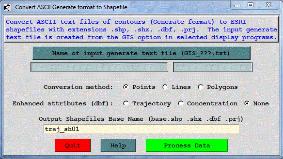
A utility tab is provided in the meteorology, trajectory, and concentration menus that will convert an ESRI generate format text file to a Shapefile for import into ArcView or comparable GIS applications. The "ascii2shp" conversion software is available under the GNU license from the Free Software foundation. The conversion can be run from the command line or the GUI menu shown below.
Normally the fields will be blank when the menu is first invoked. Prior to creating the shapefiles it is necessary to create the "Generate" text file which contains the latitude-longitude points of each contour as created by the contouring programs available through the display menus. Checking the GIS box in the menu (-a1 option on the command line) creates these files. All generate format files start with GIS and end with .txt. The remainder of the file name depends upon the application from which it was created. However in all applications, the two-digit string prior to the .txt identifies the frame number. There is one GIS output file per frame. Use the upper browse button to set the generate format input file name.
The generate files can be converted to shapefiles consisting of points or lines (for trajectories), and lines or polygons (for concentrations). Polygons are closed lines. A polygon that runs off the map display is becomes a line and may not be displayed correctly if treated as a polygon.
Normally the base.dbf file will contain only the minimum amount of information. However, the trajectory and concentration plotting programs automatically create an enhanced attributes file (GIS_???.att). To add this information to base.dbf, check one of the enhanced attributes options.
In the lower text entry box enter the base name of the output shapefiles. All output files will be created in the working directory. Note that depending upon the upper level menu from which the conversion was called, the shapefile conversion will be either for lines (meteorology), points (trajectory), or polygons (concentration), although the option can be superseded by the checkbox selection. What is a Shapefile?The Shapefile format is a working and interchange format promulgated by ESRI for simple vector data with attributes. It is apparently the only file format that can be edited in ARCView 2/3, and can also be exported and imported in Arc/Info. An excellent white paper on the shapefile format is available from ESRI, but it is .pdf format, so you will need Adobe Acrobat to browse it. The file format actually consists of four files.
The source for the Shapefile C Library is (c) 1998 Frank Warmerdam, and released under the following conditions. The intent is that anyone can do anything with the code, but that I do not assume any liability, nor express any warranty for this code.
As of Shapelib 1.2.6 the core portions of the library are made available under two possible licenses. The licensee can choose to use the code under either the Library GNU Public License (LGPL) described in LICENSE.LGPL or under the following MIT style license. Any files in the Shapelib distribution without explicit copyright license terms (such as this documentation, the Makefile and so forth) should be considered to have the following licensing terms. Some auxiliary portions of Shapelib, notably some of the components in the contrib directory come under slightly different license restrictions. Check the source files that you are actually using for conditions.
Default License TermsCopyright (c) 1999, Frank Warmerdam
This software is available under the following "MIT Style" license, or at the option of the licensee under the LGPL (see LICENSE.LGPL). This option is discussed in more detail in shapelib.html. Permission is hereby granted, free of charge, to any person obtaining a copy of this software and associated documentation files (the "Software"), to deal in the Software without restriction, including without limitation the rights to use, copy, modify, merge, publish, distribute, sublicense, and/or sell copies of the Software, and to permit persons to whom the Software is furnished to do so, subject to the following conditions:
The above copyright notice and this permission notice shall be included in all copies or substantial portions of the Software. THE SOFTWARE IS PROVIDED "AS IS", WITHOUT WARRANTY OF ANY KIND, EXPRESS OR IMPLIED, INCLUDING BUT NOT LIMITED TO THE WARRANTIES OF MERCHANTABILITY, FITNESS FOR A PARTICULAR PURPOSE AND NONINFRINGEMENT. IN NO EVENT SHALL THE AUTHORS OR COPYRIGHT HOLDERS BE LIABLE FOR ANY CLAIM, DAMAGES OR OTHER LIABILITY, WHETHER IN AN ACTION OF CONTRACT, TORT OR OTHERWISE, ARISING FROM, OUT OF OR IN CONNECTION WITH THE SOFTWARE OR THE USE OR OTHER DEALINGS IN THE SOFTWARE.